OMEGA GEOMATICS CASE STUDY
How OmegaGeo halved registration processing time with Vercator Cloud

As a leading survey company, Omega Geomatics must keep up to speed with the latest innovations in the Geomatics industry. One of the areas that has seen big leaps forward in technology has been Terrestrial Laser Scanning. The latest scanning packages have on-board processing and intelligent sensors to help with scan placements.
Before looking at investing in new equipment mid-2021, Omega was curious to see if they could prolong the life of their existing fleet of Laser Scanners using existing software in the market to improve productivity. The intention was to allow major cost savings in the annual budget for investment into other areas of the business. They initiated an R&D project with the intention of presenting the findings to their senior management team for a review before implementation of the new system, if it could be proved to provide cost and time savings.
Omega has three Faro X-series laser scanners amongst its scanning fleet. The workflow with these systems was to scan in various positions and then undertake the registration of the scans on a site laptop or desktop PC in the office. A typical registration for the laser scan of a small house (30-50 Scans) may be up to 1.5 hours of work for a surveyor. Typically, the Surveyor would carry this out on a separate day in which they have a few projects to register.
Omega looked at various software packages available and after some research it seemed that Correvate's Vercator software looked the most suitable for their needs. Omega carried out a pilot project with Vercator to assess its performance, which you can read about further down this page in the pilot project section.
Using Vercator Cloud
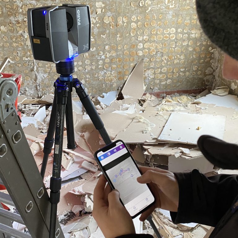
Vercator is an entirely cloud-based software in which the scans can be uploaded and registered on the cloud direct from site. The software also has a mobile app that allowed the on-site registration to be undertaken. This was the aspect that most appealed to Omega as they had seen that the 'fitting together' element of scan registration was the most time-consuming part of the process. It is also the one part of the process where 'human error' can greatly influence the end accuracy of the project which can come from scans being misaligned with one another. The app allows the Surveyor to place and link the scans together in a network. By linking the scans together, the Surveyor can, at a glance, check that his registration network is correct and the algorithm within the software will link the correct scans together during processing.
The pre-existing process Omega had been using was an office based initial Top View registration of a cluster of scans using Faro Scene, then a cloud to cloud registration. If the building is repetitive then the risk of incorrect placements is increased due the software not being intelligent to understand exactly which scans should be linked to one another. Manual registration would then be required to move the scans into their correct placements. This was an area of inefficiency within the business that they wanted to eradicate when these older scanners were used on projects.
From Omega’s first successful pilot it was clear that there were cost & productivity savings by using Vercator, and Omega would be able to continue to use their existing scanners without upgrading to newer models. These savings are scalable relevant to the size of a scanning project. The larger the project, the greater the cost savings achieved.
Time saving
Site time: existing and new methods are similar. We have not recorded any difference to date. We have seen Surveyors are able to use the app and upload with no change to the site time we have quoted for.
Office Time: Time spent in Faro Scene was twice the time cost of processing in the Vercator Cloud with the requisite saving in labour. In Vercator, the main office processing was the application of the Survey control. There are also very brief log ins needed to start the export of the data, but these take less than a minute and can be done remotely by any member of staff.

Brett Duffield, Director at Omega Geomatics says:
“The time saving on this project’s office time was around 83%. This was a significant productivity saving and after several supervised tests the software is now in full use after sustained results. As a minimum we had previously had 1.5 days a week of processing that the 3 scanning teams would create, which is no longer required as the teams are able to process on the same day. This equates to a significant saving in fees per week while allowing us to take on more work.”
Vercator Cloud Pilot Project
Brett Duffield, Director Omega Geomatics
We picked a 4 bed detached house as the test project. In the interest of transparency, I consulted with the client to see if they would mind me using a live project as a test, my reason for this was that there was a risk of delays to the client if the project did not go according to plan. The client did not have any concerns as to delays, however they did enquire if the accuracy would be to the same level of detail they normally received. I was able to remove any concerns the client had as I had a contingency plan to undertake the survey in a method which would allow me to use our existing software as a benchmark for data comparison. By doing this it would be able to prove some of the processes in Vercator were producing the correct results.
The project specification was for a Band D Measured Building Survey. This level of project has a presentation scale of 1:50 and a rule of thumb guide to the accuracy is that it has a +/- 15mm global accuracy tolerance.
I split the house into an External, Ground and First floor clusters of scans. The reason for this is to improve the accuracy overall of the project. Each linked scan will have a degree of error in linking them together. By having a high level of point overlap and point visibility (explained below) then these errors can be small enough to have a cumulative effect that will normally be only 1-3mm on a project of this size.
On site with the Vercator Field app
The app was very simple to use, clear and concise. I have shown the app to the team and on average they are able to use it and understand the features within 10 minutes. I imported site and floor plan images to use as a background image. By having this plan in the app you can easily locate each scan and understand how the scans are linked in the network.
The external scans were undertaken using 1/4 resolution, with point density of 6mm between points at 10 metres distance and with interior scans at 1/8 @ 12mm density. Whilst scanning at 1/4 resolution the Surveyor normally has just over 4 minutes of 'down time'. It is not practical to undertake complex tasks in this time, there is a security and risk to the public whilst this the scan is taking place. Therefore I had hypothesised that this 'down time' would reduce the office based processing time, if the Surveyor did the linking network whilst scanning. This proved to be a very simple task and had no effect on site time, even on the indoor scans which are just over 2 minutes. Given the average size of the rooms in the house the maximum distances I was expecting between any linked scans was to be around 4 metres. This would result in a maximum space between points at this distance of 5mm.
Once all the scans were complete, I uploaded the scans to the cloud using an unlimited 4G mobile data connection. This took around 20 mins and in that period of time I then undertook the survey control with a Leica 1200 Total Station. This was measuring the checkerboard targets that corresponded to the relevant clusters. By having a closed traverse I can ensure that the survey control is within tolerance. I was then able to set the scans processing having matched the App data to the corresponding scans. The software indicates that the networks are correct and linked via a map with linked icons. This allows the Surveyor to check before proceeding. I was then able to start the auto process before leaving site and returning to the office.

Processing with the Vercator Cloud
The first checking stage is course registration. Each scan is linked to the next scan within the network in matched pairs.
The results are displayed in two simple to read columns showing overlap and visibility. More can be read about these values in the Knowledge Base here.
Based on the initial settings and tolerances used for the project then values outside the set tolerance are coloured orange and red based on the degree to which there are outside the tolerances. Green values indicate that there is a strong link between the scans The scans themselves can be visually check by creating a slice through the data to look for any alignment anomalies. Once the Surveyor is happy with the data they can proceed to the next stage. More can be read about the Vercator registration technology here.
The next stage is fine registration. The fine registration processing tries to find the best global fit of the data. A secondary visual alignment check can be done at this stage. More detail on this can be read here.
These two above stages are automated and can be done in the background whilst other tasks are being done by the Surveyor on site or by the Surveyors assistant whilst driving back to the office.
Time spent travelling was also an unidentified area of down time within the business. By using this new software there are two parts of the existing processing workflow that could be incorporated into this directly correlates to a cost saving.
The last stages are very simple. The Survey control checkerboards are picked and applied to the imported control. A transformation is applied and the results are viewed within a report which can be saved for future reference. The Scans are then exported to a common format from a list of several industry standard point cloud formats. These can be downloaded when the email notification is received.
Why not have a chat with us and book a demo?